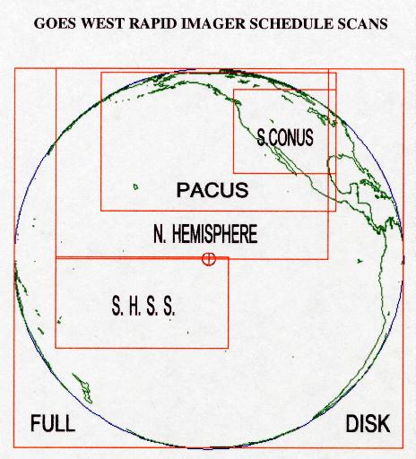
Skip Navigation Link
NESDIS banner image and link to NESDIS
Satellite Services Division banner image and link to SSD
link to the NOAA Home pageLink to the National Environmental Satellite, Data, and Information Service Home Page Default
DOC / NOAA / NESDIS / OSDPD / SSD
 
Our Mission / Disclaimer / Privacy Policy

Link to Fire ProductsLink to OSEI PagesLink to Precipitation ProductsLink to Satellite InformationLink to Snow ProductsLink to Tropical ProductsLink to Volcano ProductsLink to Winds ProductsLink to Geographical Information System Products  

GOES-WEST Imager - Rapid Scan Scanning Strategy


Rapid Scan Coverage Map Graphic Only

Effective November 1, 1999: New GOES-WEST Standard RSO Sectors:

  • Hawaii RSO Sector
  • Alaska RSO Sector
  • Sitka RSO Sector
  • TPARC RSO Sector

  • GOES-WEST RAPID SCAN SCHEDULE SECTORS

    SECTOR                   liNES               PIXELS          DURATION
                       STARTNS - STOPNS    STARTEW - STOPEW     MINS:SECS
    N. HEMISPHERE         2472 -  7888        7890 - 21130        10:15
    PACUS                 2592 -  6520       10099 - 21510         6:35
    SUB-CONUS             3056 -  5440       16539 - 21510         2:18
    S. HEMISPHERE S.S.    7824 - 10440        7890 - 16311         3:34
    FULL DISK             2472 - 13288        5852 - 24829        26:06


    External Link Indicator Indicates a link outside the U.S. Government.


    Contact Information:
    You are Here: http://www.ssd.noaa.gov/PS/SATS/GOES/WEST/rso.html
     
    SSDWebmaster@noaa.gov