DOC
/
NOAA
/
NESDIS
/
OSPO
/
SPSD
Search OSPO Sites:
Home
About US
About OSPO
Contact Us
Mission & Strategy
Disclaimer
Privacy Act Statement
Product Listing Page
Atmosphere
-- Aerosol
-- Clouds
-- Ozone
-- Precipitation
-- Radiation Budget
-- Soundings
-- Volcanic Ash
-- Winds
bTPW
CoastWatch
Hazards
Imagery
-- Archives
-- Composites
-- Geostationary Server
-- Land
-- Ocean
-- OSEI
-- Polar Composites
Land
-- Fire & Smoke
-- Snow & Ice
-- Surface & Hydrology
-- Vegetation
MIRS
MSPPS
Ocean
-- Coral Bleaching
-- Ocean Color
-- Sea/Lake Ice
-- Sea Surface Height
-- Sea Surface Temperatures
-- Tropical Systems
Special Imagery
Geographical Information Systems (GIS)
Operational Special Events Imagery (OSEI)
Historical Page
Special Tropical Cyclone Pages
-- Katrina '05
-- Rita '05
-- Wilma '05
-- Sandy '12
-- Haiyan '13
NOAA Environmental Visualization Laboratory (EVL)
Geostationary
GOES Image Server
-- Composites
-- Land Sectors
-- Ocean Basins
-- OSEI
-- Tropical Floaters
-- Tropical Atlantic
-- Tropical Pacific
-- Severe Storms
Polar
MIRS
MSPPS
Atlantic Composites
Pacific Composites
Satellite Services
Argos DCS
EMWIN
GEONETCast Americas
GOES DCS
LRIT
NOAASIS
SARSAT
---- Satellite Information ----
GOES
-- Satellite Status
-- Special Bulletins
-- Eclipse Schedules
-- Dissemination Schedules
METEOSAT
MTSAT-1R
POES
-- Satellite Operations
-- Satellite Status
Pre-Processing
-- Dissemination Schedules
Original SSD Links
SSD Fire Products
Precipitation Products
Satellite Information
Snow and Ice Products
Tropical Products
Volcano Products & the Washington VAAC
Winds
Geographical Information System Products
Tropical Products
Active Tropical Cyclones
Positions/Intensities:
Dvorak Classifications
Eastern Hemisphere
Bulletins
|
Archive
Microwave Positions
Advanced Dvorak Technique (ADT)
Rainfall:
Ensemble Tropical Rainfall Potential (eTRaP)
Automated eTRaP Information
Explanation of the Digital eTRaP Format
Surface Wind:
GOES-Based Multi-Platform Tropical Cyclone Surface Wind(MTCSWA)
Tropical Cyclone Formation Probability:
Tropical Cyclone Formation Probability(TCFP)
Satellite Imagery:
Atlantic Storm Floaters
Pacific Storm Floaters
Operational Significant Event Imagery
Tropical Cyclone Formation Probability Product:
- provides a broad-scale "first guess" at areas
with the potential for TC formation
Atlantic, EPAC and WPAC Genesis Parameters
Backup site Genesis Parameters
Genesis Parameters from 2000 - present
Other Information
More information about our Tropical Products:
The SSD Tropical Program - coming soon
The Dvorak Classification
Technique
Tropical Storm
Current Intensity Chart
Additional Satellite Imagery:
Geostationary Satellite Server - Hurricane Sectors
Imagery System Status
Links to Outside Tropical Products (Text):
NOAA
National Hurricane Center
Forecasts
NOAA
Central Pacific Hurricane Center
Forecasts
Joint Typhoon Warning Center
Products
Case Studies:
First South Atlantic Hurricane - Catarina (2004)
Heavy Precipitation Auto-Estimator - Tropical Storm Allison (2001)
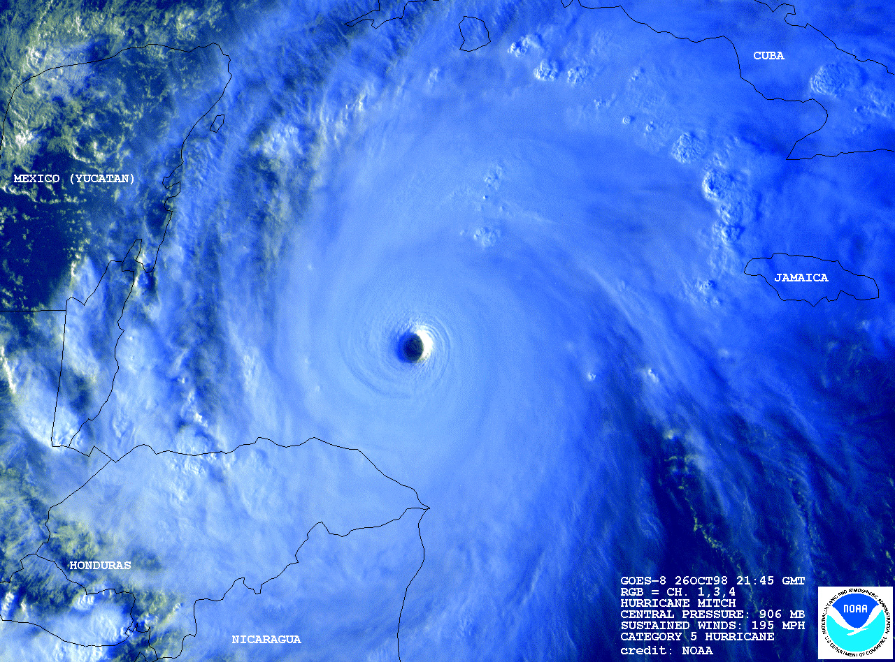
Operational Significant Event Imagery - Hurricane Mitch (1998)
Links to Outside Tropical Products (Imagery and Graphics):
Navy Research Laboratory - Tropical Satellite Products
University of Wisconsin SSEC Tropical Cyclone page
Colorado State University RAMMB/CIRA TC page
ASCAT Scatterometer Winds
NOAA/NESDIS ORA Storm Centered Derived Winds
CIMSS ADT
Indicates a link outside the U.S. Government.


