

The Satellite Services Division (SSD) is part of the Office of Satellite Data Processing and Distribution (OSDPD). We (SSD and OSDPD) are part of National Environmental Satellite Data and Information Service (NESDIS). NESDIS is part of the National Oceanic and Atmospheric Administration (NOAA), and the Department of Commerce. Currently, the Satellite Services Division is composed of two Branches: Satellite Analysis Branch (SAB) and Product Implementation Branch (PIB).
At this web site you will find information and links to SSD products and services in support of the NOAA mission to provide support to the public in the form of satellite imagery and derived satellite products.
Here are brief mission statements for SSD, SAB, and PIB:
EC2000 SATELLITE SERVICES DIVISION E/SP2
David Benner - Division Chief
The Satellite Services Division serves as the primary interface with the user community of environmental satellite data and products. The Division provides, analyses, blended products from polar orbiting and geostationary satellites, and interpretive services. These satellite products are distributed to a diverse user community for a broad range of environmental applications. The Division maintains an operational satellite data distribution network providing user access to real-time or near real-time environmental data and information. A quality assurance program is used to systematically evaluate and manage the satellite products and services, and to ensure continuous product improvement. Working with other organizations within NESDIS and NOAA, new products are tested, evaluated, and implemented when deemed operationally useful. In partnership with other agencies, the Division evaluates and deploys new technologies to satisfy emerging requirements. SSD PowerPoint Briefing
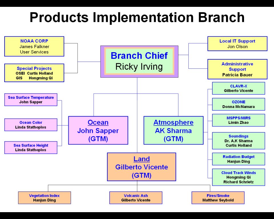
EC2200 PRODUCT IMPLEMENTATION BRANCH E/SP22
Antonio "Ricky" Irving - Branch Chief
The Product Implementation Branch (PIB) ensures the seamless transition of products and analysis techniques from research to operations. The Branch works closely with the NESDIS Office of Research & Applications (ORA), the Joint Center for Satellite Data Assimilation (JCSDA), and NWS’ National Centers for Environmental Prediction (NCEP) to ensure that advanced satellite data and analysis techniques are incorporated into NOAA’s numerical modeling activities. PIB continuously monitors the quality of NESDIS operational product portfolio, evaluates system performance for each assigned product, and provides corrective maintenance and adaptive software maintenance for those products, as needed. The Branch utilizes interactive processing technology to integrate multiple satellite sensor data streams into new blended operationally support products. The Branch serves as the NESDIS focal point for the development of new major digital products, and for the development and implementation of interactive workstation technology, and image processing capabilities used for operational applications of environmental satellite data. PIB Organizational Chart
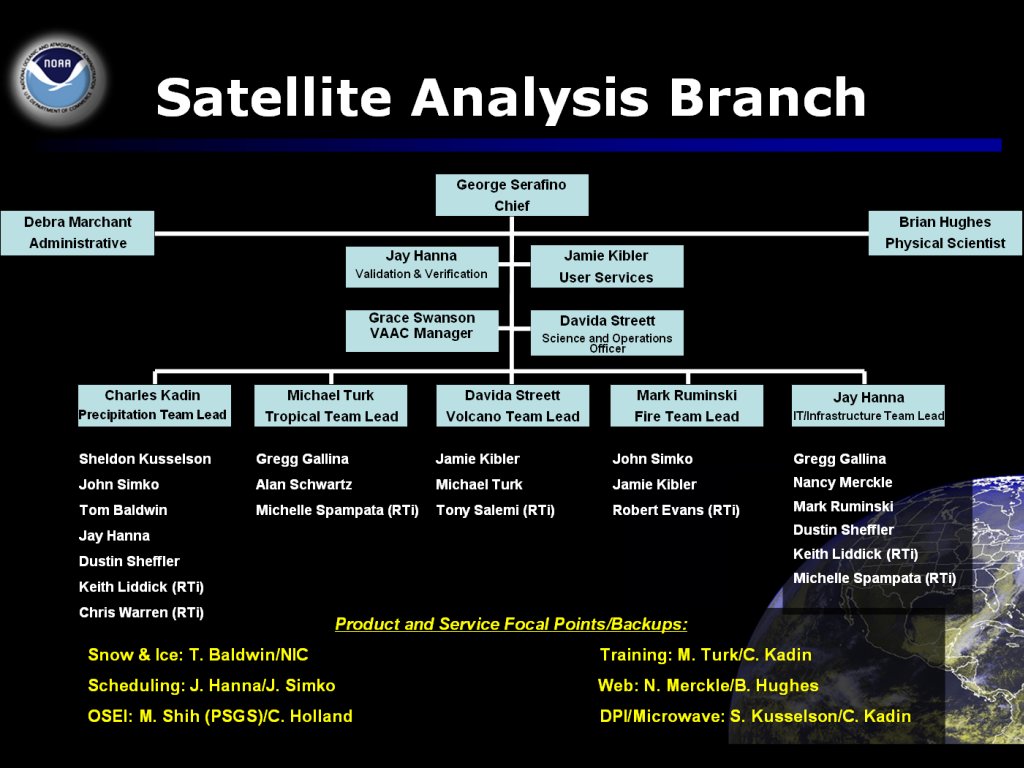
EC2300 SATELLITE ANALYSIS BRANCH E/SP23
Davida Streett - Branch Chief
The Satellite Analysis Branch serves as the operational focal point for real-time imagery products and multi-disciplinary environmental analyses within NESDIS. The Branch's primary mission is to operate new proof of concept satellite analysis techniques needed to support disaster mitigation and warning services for U.S. Federal agencies and the international community. Prototype environmental analyses are provided to NWS Warning & Forecast Offices, NCEP Centers, and to oceanographic and other environmental users of NESDIS satellite products. The Branch works closely with its operational partners to assess the utility of these new satellite analyses. Once the analyses have been proven to have operational value, the Branch transitions responsibility for continued operational production to the appropriate operational partner. The Branch schedules and distributes real-time satellite imagery products from global geostationary and polar orbiting satellites for dissemination to environmental customers. SAB Organizational Chart - SAB PowerPoint Briefing
SPSD's Web Services - Brief Descriptions
SPSD Home Page - Links to the products and services offered by the Satellite Products and Services Division
Geostationary Satellite Server - Realtime geostationary satellite imagery from NOAA's geostationary satellite and other international geostationary satellites
![]() Indicates a link outside the U.S. Government.
Indicates a link outside the U.S. Government.