


NOTE: NESDIS maintains the official operational product, which can be found at www.ssd.noaa.gov/PS/TROP/TCFP/index.html.
NCEP global analyses and GOES-East, GOES-West, MTSAT-1R and Meteosat-7 channel-3 (water vapor) imagery are used as input to an algorithm to estimate the probability of tropical cyclone formation within the next 24 hours in 5 by 5 degree latitude/longitude areas from 45 S to 45 N and 0 to 360 E. The product domain is divided into 7 main basins (below) based on satellite coverage and warning agency boundaries.

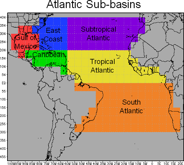
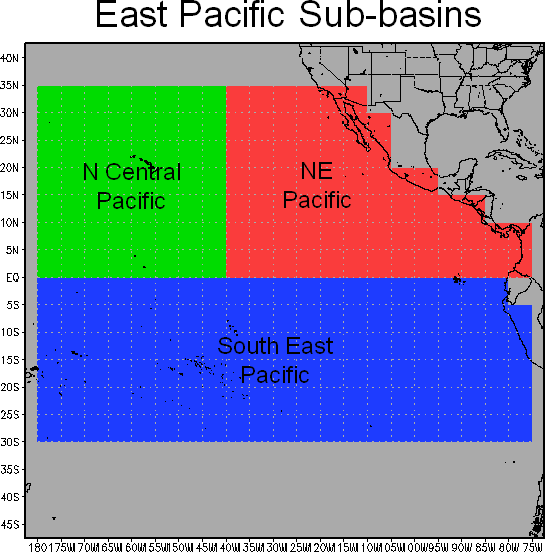
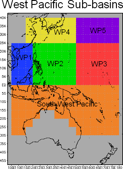
Figure: TCFP basins
The probability estimates are based upon the following input parameters:
- CLIMATOLOGICAL FORMATION PROBABILITY: This was derived from the NHC Atlantic and east Pacific best track files from 1949-present. Formation was defined as the first point for each storm in the best track after all extratropical cases were excluded.
- PERCENT LAND: The percent of each 5 by 5 degree square over land
- DISTANCE TO PREXISTING STORM: The distance from the center of each 5 by 5 degree grid box to existing tropical cyclones.
- REYNOLD'S WEEKLY SST: The average weekly Reynold's SST in each 5 by 5 degree grid box.
- VERTICAL SHEAR: The 850-200 hPa shear determined by averaging the 850 hPa and 200 hPa wind vectors over each 5 by 5 degree area, and then calculating the magnitude of the shear vector.
- 850 HPA CIRCULATION: The 850 hPa circulation determined from a line integral of the wind component tangent to the boundary of each 5 by 5 degree area.
- VERTICAL INSTABILITY: The vertical average temperature difference between the equivalent potential temperature of a parcel lifted from the surface to 200 hPa, and the saturation equivalent potential temperature of the environment, for each 5 by 5 degree area.
- 850 HORIZONTAL DIVERGENCE: The 850 hPa horizontal divergence determined from the average zonal and meridional winds along the boundaries of each 5 by 5 degree area.
- COLD PIXEL COUNT: The percent of channel 3 pixels colder than -40 degree C in each 5 by 5 degree area. All full disk images within 3 hours after and 6 hours before each synoptic time are include, so that this parameter represents the amount of sustained deep convection.
- CLOUD-CLEARED WATER VAPOR BRIGHTNESS TEMPERTATURE: The average channel 3 brightness temperature, after the cold pixels in parameter 9 above have been eliminated. This parameter is a measure of mid- to upper-level moisture.
- MEAN SEA LEVEL PRESSURE ANOMALY: The MSLP - climatological MSLP in each 5 by 5 degree grid box.
The formation probability is calculated by a screening step, followed by a discriminant analysis.
In the screening step, the probability of formation is set to zero for 5 by 5 degree areas where formation almost never (ie, less than 5% of sample genesis cases) occurred based upon the best track data (1949-present), NCEP reanalysis fields (1981-present), and Satellite Water Vapor climatology.
Screening Parameters:
| TCFP set to 0% if ... | Atlantic | N.E. Pacific | N.W. Pacific | Indian Ocean | S. Pacific | |
|---|---|---|---|---|---|---|
| Latitude (°N) | < | 5.0 | 5.0 | N/A | N/A | N/A |
| Percent of Grid Box Area Over Land (%) | = | 100 | 100 | 100 | 100 | 100 |
| 850 hPa Circulation (kt) | < | -2.9 | -2.5 | -1.6 | 0.1 | -1.1 |
| Vertical Shear (kt) | > | 45.3 | 28.9 | 36.4 | 43.8 | 46.9 |
| Vertical Instability (°C) | < | -2.6 | -3.4 | 0.6 | -4.9 | -3.3 |
| Horizontal Divergence (x10-5 s-1) | > | 3.2 | 2.4 | 1.6 | 2.7 | 2.1 |
| Satellite Water Vapor Cold Pixel Count (%) | < | 1.2 | 2.7 | 3.1 | 3.5 | 4.7 |
| Satellite Water Vapor Brightness Temp (°C) | > | -23.4 | -21.1 | -23.5 | -25.3 | -20.5 |
| Reynold's SST (°C) | < | 21.9 | 25.8 | 27.4 | 26.5 | 26.1 |
| MSLP Anomaly (hPa) | > | 3.1 | 2.1 | 2.3 | 0.9 | 2.3 |
| Distance to Nearest TC (km) | < | 200.0 | 200.0 | 200.0 | 200.0 | 200.0 |
After screening, the input parameters listed below are used to calculate a linear discriminant function value for each 5 x 5 degree grid box. These linear discriminant function values are then converted to TC formation probabilies using a statistical relationship derived from past cases. Details on this procedure can be found in Schumacher et al. (2007).
Discriminant Analysis Inputs:
- Climatological formation probability
- 850 hPa Circulation
- GOES Cold Pixel Count
- Distance to Pre-Exisiting Tropical Cyclone
- Vertical Shear
- Percent of Area Over Land
- 850 hPa Horizontal Divergence
To provide some time continuity of the product, the formation probability and the primary parameters used in the screening and discrimination analysis are summed (probabilities) or averaged (all other parameters) over 6, 3, 6, and 3 sub-basins for the Atlantic, Eastern Pacific, Western Pacific, and Indian Ocean basins, respectively. Time series products comparing the current and climatological parameters over the sub-basins are provided on the web site.
 |
 |
 |
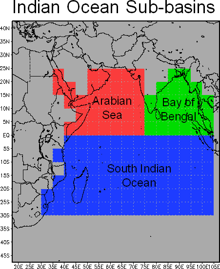 |
| Figure: TCFP sub-basins |
References:
Schumacher, A. B., M. DeMaria, J. A. Knaff, 2009: Objective Estimation of 24-h Probability of Tropical Cyclone Formation. Wea. Forecasting, 24, 456-471.
